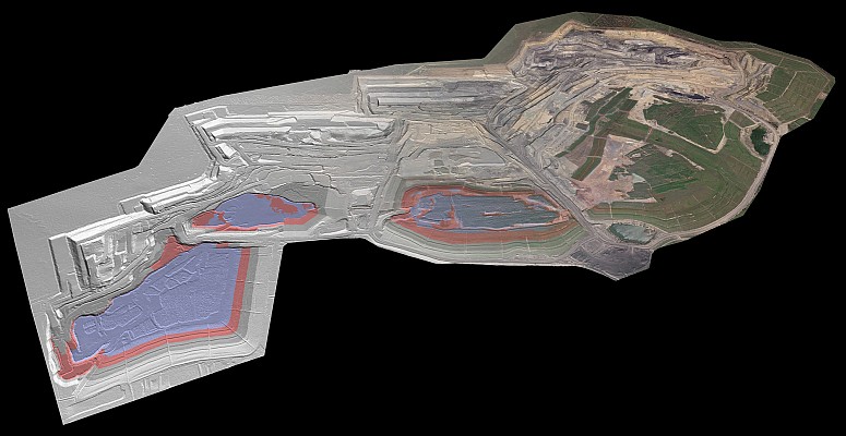
EOMAP Asia Pacific today launch the most up-to-date and detailed data set for the islands in South China Sea, generated by groundbreaking Satellite Derived Bathymetry techniques close to the disputed territories of several countries with Asian region.
 The atolls are several hundred km away from the nearest coast and are surrounded by water deeper than 1000m, which is assumed to hold extensive of oil and gas reserves. Instead of relying on traditional surveying vessels or aircraft to map the many ‘un-mappable’ areas of the reef, Germany-based aquatic remote-sensing company EOMAP used space-borne satellites to overcome these hurdles”. After the mapping of the entire Great Barrier Reef of Australia, the Mexican Riviera Maya and the Abu Dhabi waters this is the next big step towards an increasing and updated bathymetric database.
A.S. Mittal, CEO EOMAP Asia Pacific commented, that “Such techniques from satellite allow us to map these islands from space and provide options for continous mapping at regular intervals. We will continue to monitor these areas for changes and provide such detailed reports to anyone who subscribes to our monitoring services. Space based monitoring programs are now a reality with multiple Imaging satellites at different resolutions. ”
Since these islands are disputed areas, traditional survey methods from vessel or aircraft would have failed to get an overview of the entire region. Under these circumstances, satellite techniques play a key role, and with the clear waters water depth up to the 25m contour line could be mapped. This is actually the depth range which is of particular importance for navigation. The data are available in a 15m bathymetric grid and on request in a 2.0m or even submeter grid using the most recent satellite imagery. All of the mapped areas, no matter how small, are available.
Dr. T. Heege, CEO EOMAP is summarizes, that “EOMAP’s bathymetric database has now extended to another important region of the world. Client’s benefits are obvious: Rapid up-to date bathymetric grid with a very attractive pricing. As an outlook to the very near future we’re setting up processing infrastructures and training modules to do in-house training and processing capabilities.”
About EOMAP
EOMAP is a world leader in aquatic remote sensing services, notably using optical sensors to derive bathymetry, seafloor and water quality products. EOMAP received several awards from Copernicus (the European Commission remote sensing peak body) for its work on making affordable aquatic remote sensing products for industry and the public sector, by using cutting-edge processing technologies.
Source: GISCafé