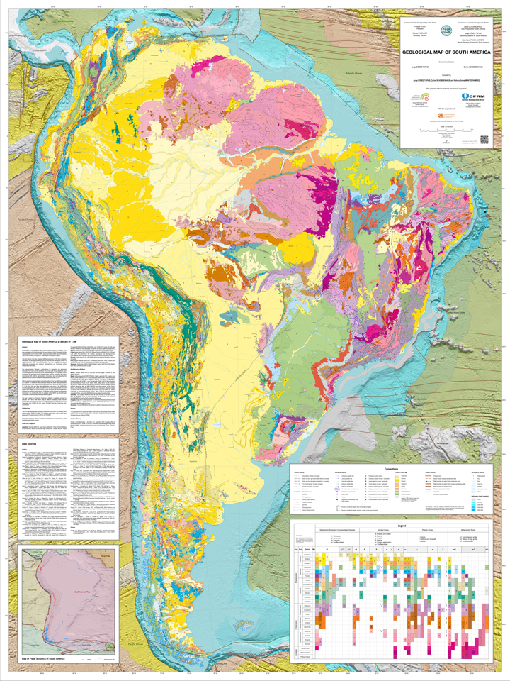
A new edition of the Geological Map of South America (GMSA) at a scale of 1:5 M was developed by the Subcommission for South America of the Commission for the Geological Map of the World (CGMW), approved by the CGMW General Assembly held in Oslo (Norway), during the 33rd International Geological Congress.
This third version has been prepared with the cooperation of the Ibero–American Association of Geology and Mining Surveys (ASGMI), the geological surveys of Argentina, Brazil, Chile, Colombia, Ecuador, Peru, and Uruguay; and several additional universities and research institutes that are mentioned in the collaborators information.
The subcommission followed a methodology for integrating the geological information from each country as follows: first, a new code was generated for each chronostratigraphic unit according to the proposed legend, by using digital layers provided by the geological survey of each country; second, symbology and colors were created with patterns representative of rock type and colors depicting the ages; and third, a map with coded units was prepared at a scale of 1:5 M.
With the objective of generalization and linking units by hand, the GMSA was printed at a scale of 1:3 M with the new codification. Next, the GMSA was scanned and georeferenced in order to generalize the geological units, faults and folds at a scale of 1:5 M. Once this was done, and despite the small–scale of the GMSA, the chronostratigraphic units, faults and folds on the map were adjusted with the aid of shaded relief images (STRM from NASA) in order to improve the matching between relief and the mapped geological units. Finally, the geology between countries was harmonized. It is worth noting that the updating of the GMSA was done through consultation of internationally indexed published papers.
The map is based on a Polyconic Projection (Latitude × Longitude), centered on Meridian –59°, WGS–1984 datum; data for offshore areas were taken from the Tectonic Map of South America at a scale of 1:5.9 M (Cordani et al., 2016); the Sea Floor Topography from GEBCO 08 Grid, version 20100927; and the Crustal Age Grid: NCEI/NOAA.