NASA selects Raytheon Company to provide three instruments and related services, with an option for one additional instrument, in support of the Landsat Next mission based at NASA’s Goddard Space Flight Center in Greenbelt, Maryland.
The contract includes a cost-plus-award-fee base period and a cost-plus-fixed-fee option period with a total value of $506.7 million. The contractor will provide the design, engineering analyses, algorithms, fabrication, testing, delivery, and support for the Landsat Next Instruments. The work will be primarily performed at the contractor’s facilities in El Segundo, California.
The Landsat Next mission is a major component of NASA’s Earth science portfolio, advancing Earth observing technologies, science, and applications. Landsat Next will continue the longest space-based record of Earth’s land surface, while transforming the breadth and depth of actionable information freely available to the public and other users across governments, industry, and academia.

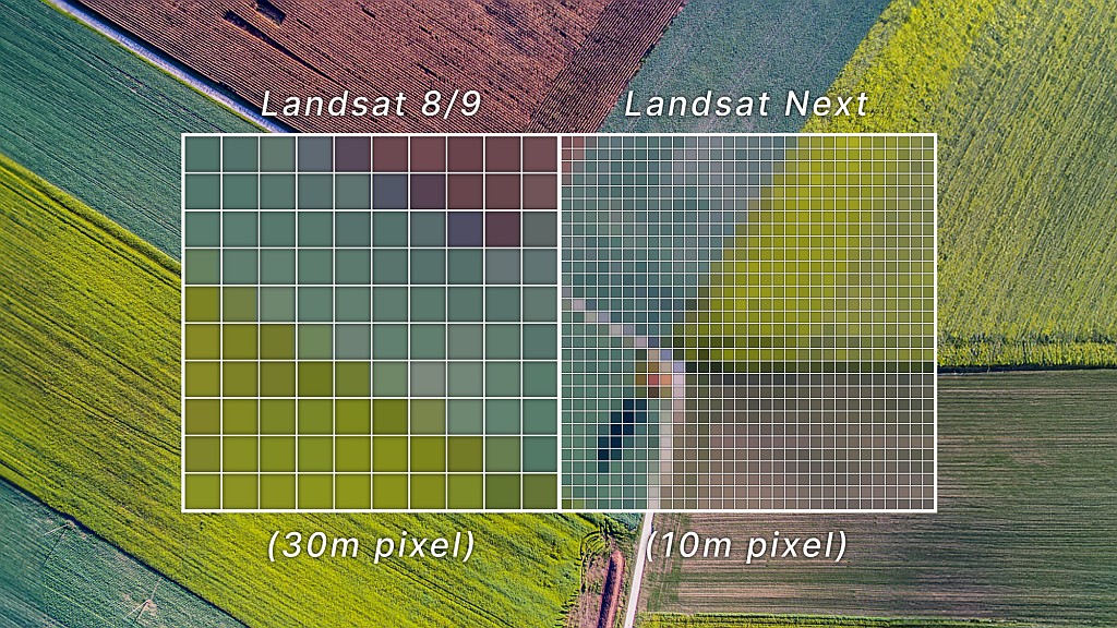
With Landsat Next, NASA is moving from a single Landsat spacecraft to developing a constellation of three smaller satellites able to deliver two to three times the temporal, spatial, and spectral resolution of previous Landsat satellites.
The new 26-band super-spectral Landsat Next constellation will enhance existing Landsat applications, building upon the 50-year Landsat legacy, improving life on Earth through climate and technological advancements, and unlocking new applications that support water quality and aquatic health assessments, crop production and soil conservation, forest management and monitoring, climate and snow dynamics research, and mineral mapping.
The Landsat Next mission is a partnership between NASA and the U.S. Geological Survey to advance Earth observing technologies, science, and applications under the Sustainable Land Imaging Program to more effectively map, monitor, and manage America’s land, water, and coastal resources.

Landsat Next: A New & Revolutionary Mission
Landsat Next, expected to launch in late 2030/early 2031, is an innovative Landsat mission that represents a quantum leap in measurement capabilities with improved temporal, spatial, and spectral resolutions. The mission will satisfy global Landsat data user needs and support evolving and emerging applications, all while maintaining Landsat data continuity and quality of the longest space-based record of Earth’s land surface.
For information, visit: https://landsat.gsfc.nasa.gov/satellites/landsat-next

