
In the era of smart cities, the convergence of drone technology, AI, distributed sensor networks, and cutting-edge connectivity is transforming urban management on a global scale. For the geospatial realm, this fusion unlocks unprecedented opportunities to enhance public services—from real-time environmental monitoring and dynamic traffic optimization to advanced surveillance and the automation of tasks-traditionally handled with labor-intensive inputs-like waste collection. By harnessing precise spatial data and aerial insights, drones are not only improving efficiency and resilience but also driving sustainability in complex urban ecosystems worldwide.
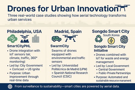
Prominent cases in the literature include SmartCityPHL in Philadelphia, which uses drones and streetlight sensors to collect and process environmental and mobility data in real time; SwarmCity in Madrid, where coordinated AI-powered drone swarms monitor traffic, crowds, and air quality; and Songdo in South Korea, an initiative that integrates drones into a smart infrastructure system for automated waste management.
Running these systems involves intricate challenges that demand thorough understanding and caution before attempting to duplicate them in other settings. For starters, planning and coordinating UAV routes requires mastering sophisticated algorithms to ensure efficient coverage and air safety. On the other hand, managing the large volumes of data generated demands a robust processing infrastructure—either through edge computing or cloud services—along with AI analytics to extract meaningful insights in real time.
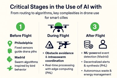
Challenges also include ensuring interoperability between multiple systems and maintaining the continuous autonomous operation of drones in densely populated areas. These complexities are the unavoidable cost of adopting advanced technologies to manage traditional local public services. Furthermore, the precise coordination required for effective implementation in high-density urban settings is a natural consequence of a rapid urbanization of the developed world. To streamline the implementation of AI-driven drones in large-scale urban projects, the complexities can be divided into three key phases of the data collection process.
- Before the flight, the main challenge lies in efficiently programming routes to ensure optimal coverage. SmartCityPHL and Songdo rely on historical data and fixed sensors for trajectory planning, while SwarmCity uses algorithms inspired by bird behavior to dynamically adjust routes in real time..
- During flight, AI monitors drone stability and safety, avoiding obstacles and coordinating cooperation between units. This particular complex issue in SwarmCity has been solved using nature-inspired algorithms due to limited intra-swarm communication and the need for simultaneous area coverage. In Philadelphia, edge computing enables immediate data processing to support rapid response to urban events. In Songdo, AI operates within an integrated IoT sensor network, enabling tasks such as automated waste collection based on optimized routes, big data, and predictive models.
- After flight, complexity shifts to data management systems. SwarmCity processes large volumes of simultaneous data from multiple drones using machine learning to detect critical urban events. Its solution includes an advanced virtual reality interface for human-machine interaction, increasing software and integration complexity. SmartCityPHL focuses on decentralized processing to streamline alerts and synthesize heterogeneous data for environmental and mobility management. Meanwhile, Songdo’s system stands out for executing automated decisions within the urban ecosystem, dynamically adjusting waste collection and energy control systems through tightly integrated, interoperable subsystems.
Moreover, environmental data collection, while vital for decision-making, demands rigorous analysis and responsible management to avoid misinterpretation or misuse. Therefore, deploying smart drones must balance technological efficiency with ethical and regulatory safeguards that protect urban well-being.
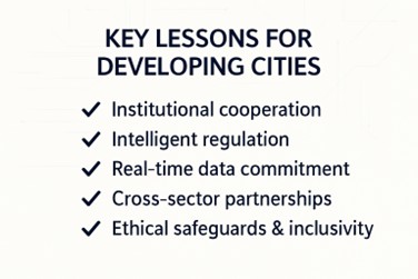
For cities across the developing world, adopting AI-enabled drones for environmental monitoring, public safety, and urban management holds tremendous promise. However, these advances face substantial hurdles: regulatory gaps, budget constraints, and a pressing need to strengthen institutional capacities. Cross-sector partnerships, especially between universities, local governments, and civic innovators, are crucial to overcoming these barriers. A shared vision and aligned incentives will be essential to ensure that emerging technologies serve inclusive, ethical, and sustainable urban futures.

* Javier Carranza Torres – Economist, AI developer, and geospatial content specialist. He has extensive experience in geospatial data training, digital integration, and innovation. He also organizes and curates technology events.
@geocensosguy
MundoGEO organizes the DroneShow, MundoGEO Connect, SpaceBR Show, and eVTOL Expo annually in São Paulo, Brazil. Check out the highlights from the latest edition:
