
DEPHOS Group will be present at MundoGeo Connect 2026, leading a Central European Geo-consortium. The focus of our presence will be solutions applied to data quality control.
DEPHOS Group is a European geomatics company founded in 2000, specializing in solutions applied to photogrammetry, laser scanning, geodesy, and 3D data acquisition. It operates as a full-service company (end-to-end cartographic cycle service), using aerial and terrestrial data collection methods to produce 3D models and cartographic data applicable in CAD and GIS systems.
The group is structured into five main divisions:
- Terramap Middle East, with a direct presence in Saudi Arabia, focused on customer proximity and service quality;
- ADRAM, an ultralight aerial mapping system that integrates LiDAR sensors, digital cameras, and inertial navigation systems;
- LiMON, advanced software for viewing, manipulating, and delivering point clouds;
- ORBIVIEW, an advanced solution for Visual Asset Management;
- Revoscan, a 3D capture system for areas such as advertising, gaming, and tourism.
With nearly three decades of experience, DEPHOS has participated in large-scale national and international projects, including coastal mapping, urban information systems, inventories, including forestry, and cultural heritage documentation. The company benefits from strong links to universities and high professional standards associated with the European Union, driving technological innovation.
DEPHOS’ approach focuses on quality, meeting deadlines, cost control, and close collaboration with the client. The team, composed of highly qualified specialists, follows a quality policy based on international standards, cutting-edge technology, continuous training, and individual responsibility.
LiMON – LiDAR Quality Control and Analysis Software
Overview
LiMON is software developed by Dephos Group to meet the growing need for quality control, visualization, and analysis of LiDAR data. Unlike other solutions focused primarily on processing and automatic classification, LiMON stands out for its intuitive approach and specialization in quality assessment. It is widely used by private companies, local and national administrations, including large cities in Poland and one of Romania’s ministries.
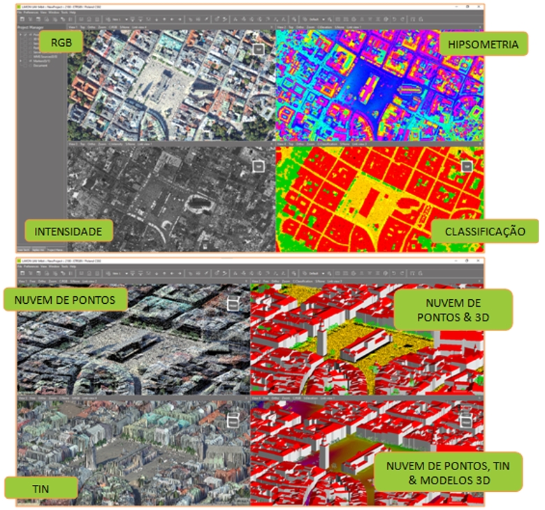
Advanced point cloud visualization
LiMON allows you to work with large volumes of data (hundreds of millions to over a billion points) without any loss of performance. It supports multiple visualization modes, such as RGB, intensity, classification, and hypsometry, as well as the creation and visualization of TIN and 3D models.
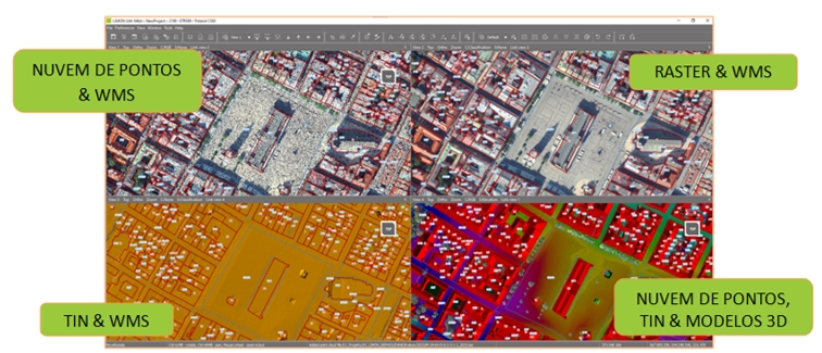
Geospatial data integration
The software supports vector and raster formats, 3D model loading, and integration with WMS services from national and regional geoportals. It is compatible with all EPSG coordinate systems, allowing transformations between systems, which is essential in contexts with multiple reference frames.
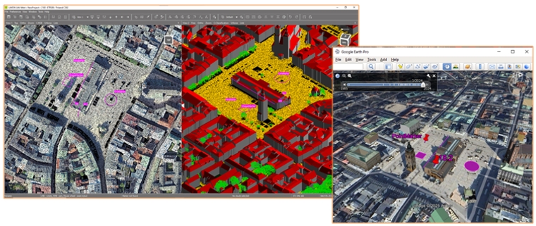
Measurement and marking tools
LiMON allows you to create point, line, and area markers that can be exported to .shp and .kml, facilitating integration with GIS software. It includes the Relative Height Marker tool, which allows you to quickly measure relative heights (e.g., buildings) based on two selected points.
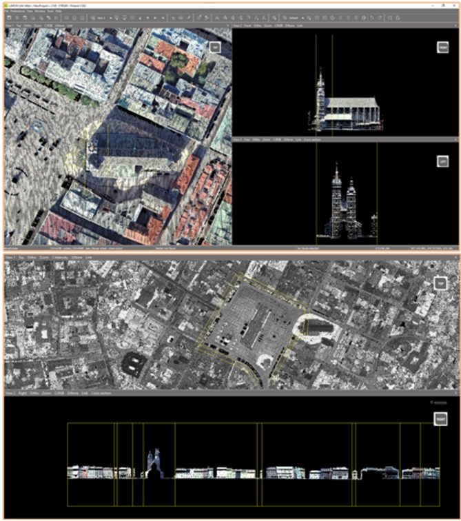
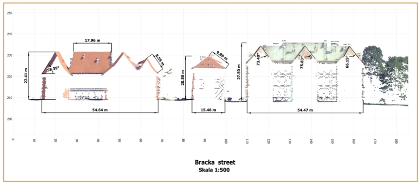
Document Module
The Document Module is one of LiMON’s core features. It allows you to take accurate measurements (linear and angular) and generate technical and legal documentation based on cross sections. It supports straight, symmetrical, and polygonal sections, and is especially useful for curved or misaligned objects.
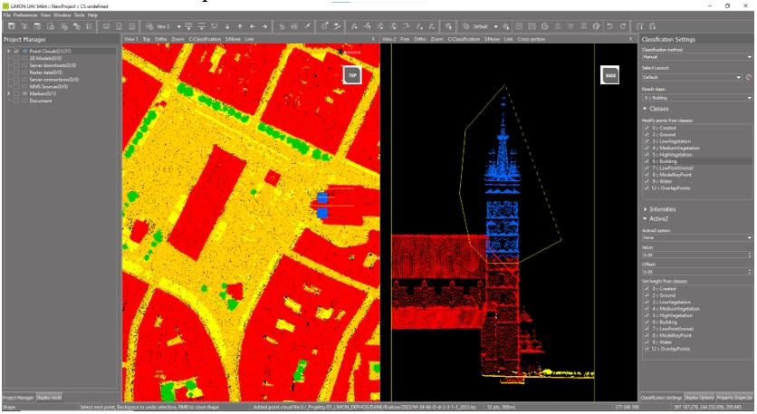
Manual point cloud classification
The software includes advanced tools for manual classification, essential for correcting automatic classification results. It allows you to classify points by intensity, relative height, polygons, or corridors, with real-time visualization in both the point cloud and the TIN.
Large data volume management – LiMON Server
For large-scale projects (e.g., entire cities), LiMON Server allows you to store data on a central server and automatically load only the necessary areas. This reduces the load on local computers and enables remote access via LAN or the Internet.
Key features (summary)
- Interface in English, Polish, Romanian, and Portuguese
- View modes: orthogonal, perspective, stereo, and sections
- Support for multiple point cloud formats and 3D models
- WMS integration
- Measurement of distances, areas, and volumes
- TIN creation
- Export of vector markers
- High performance with large data volumes
- Compatible with Windows 11
For further information: www.limon.eu / mprochaska@dephos.com
DEPHOS is confirmed as an exhibitor at DroneShow, MundoGEO Connect, SpaceBR Show, and Expo eVTOL 2026, which will be held from June 16th to 18th at Expo Center Norte – Blue Pavilion, in São Paulo (SP).
Check out the schedule of courses, seminars, and forums at DroneShow Robotics, MundoGEO Connect, SpaceBR Show, and Expo eVTOL. Registration is available in advance with a discount, and spaces are limited.
See the highlights from the last edition:
