DroneMetrex, a manufacturer of the TopoDrones – the unique and true photogrammetric mapping UAV systems, introduced a revolutionary solution for Directly Georeferenced Mapping from UAVs. The difference and, at the same time, the main advantage of the Direct Georeferencing Solution offered by DroneMerex is that it encompasses Post Processed Kinematic (PPK) principles.
“We went this way because Real Time Kinematic (RTK) has radio-link issues and distance issues. It is limited to the telemetry range and other radio frequency interferences (terrain, vegetation, buildings, atmospheric conditions, etc). RTK accuracy reduces as distance increases. If loss of radio frequency or telemetry during the flight happens – you have missing data which will compromise the accuracy of the whole flight run”, DroneMetrex Managing Director Tom Tadrowski says.
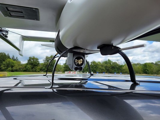
An important component of PPK Direct Georeferencing Solution offered by DroneMetrex is a high accurate GPS receiver on board of the TopoDrone which independently logs the GPS coordinates of the drone for each and every photo position.
The accuracy of the photo position is also directly related to the synchronisation of the camera shutter with the GPS logging. Having that in mind, DroneMetrex specialists modified the internals of the camera and synchronised L1/L2/Glonass/BDS antenna to the nano-second of the camera shutter to achieve highest mapping accuracy.
Another crucial aspect that received much attention of DroneMetrex experts is the position of the on-board GPS antenna in relation to the camera. Unless the antenna is exactly above the camera, and unless the camera is nearly nadir and with little or no “crab” then there is always a danger of having geometric errors that will inevitably occur during the flight. The TopoDrone-100 has the GPS antenna mounted directly and accurately above the centre of axis to the Dynamic Stabilised Active Mount and the camera. It ensures minimum “lever-arm” correction for highest accuracy photogrammetry. Differential GPS post-processing is then used to obtain the accurate camera positions.
As a result of this game-changing approach DroneMetrex clients successfully map significantly larger areas with challenging types of terrain (dense forests, coastal zones, mining sites) without any ground control points. The clients enjoy dramatically improved photogrammetric accuracy of their mapping products and significantly reduced data processing time.
About DroneMetrex
DroneMetrex Pty Ltd is a company specialising in the autonomous data acquisition, near real-time data feeds, and accurate survey and photogrammetric mapping information services from “Drones”. This provides alternative solutions to costly data acquired from aircraft or similar airborne and/or vehicular platforms over areas that are not economically justified to be captured by such large aircraft, or may be difficult and/or dangerous for “manned” aircrafts or vehicles or ground survey teams. With the TopoDrones the company produces truly accurate mapping data – 25mm accuracy in height – reliably, repeatedly, accurately.