SBG SYSTEMS joins YellowScan® to present the lightest LiDAR in the world at the Intergeo trade show in Stuttgart. YellowScan® is the lightest LiDAR in the world for fixed or rotary wings UAVs while being highly efficient and easy-to-use. YellowScan® embeds an Ellipse-E, the miniature inertial navigation systems from SBG SYSTEMS which helps obtaining a clear and accurate point cloud.
The UAV market is continuously growing, especially for professional applications like 3D surveying. Developed for this application, YellowScan®has been designed to be the lightest all-in-one LiDAR in the world. It can be easily mounted on rotor or fixed-wings UAVs. To finely adjust the YellowScan®, the R&D team has been working closely with researcher and professionals of several industries such as Construction, Surveying, Mining, and the study of forest, rivers, etc. It results in a comprehensive, high performance, and easy-to-use LiDAR.
YELLOWSCAN®, THE READY-TO-USE LIDAR
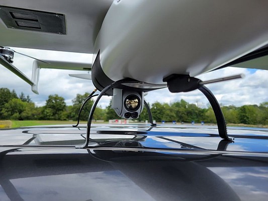
YellowScan® is a ready-to-use LiDAR, which is operational at up to 75 meters. It delivers a highly dense point cloud accurate to 10/15 centimeter. This comprehensive solution includes a LiDAR with a ±50 degree angle that measures 40,000 points per second, an Ellipse-E inertial navigation system coupled with a centimeter-level RTK GPS, an on-board computer, and an integrated battery.
Once mounted on the drone, the user pushes the yellow button and YellowScan® is ready to survey. LED lights give useful information on YellowScan® state, for instance if the GPS is receiving RTK corrections or not. The user can launch the UAV and begins the survey. Once the task accomplished, a USB stick is used for downloading the data. An office software is also delivered to visualize the point cloud in a few clicks, before opening it in an industry specific software like Terrasolid, AutoCAD, ESRI, etc.
THE ELLIPSE-E FOR MOTION COMPENSATION AND DATA GEOREFERENCING
YellowScan® research and development team was searching for a high performance, light, and ITAR free inertial navigation system for motion compensation and data georeferencing. They tested the Ellipse-E, the new miniature inertial navigation systems from SBG. Weighting only 12 grams as OEM version, it provides roll and pitch data accurate to 0.2 degree. The heading is accurate to 0.5° with only one antenna. Indeed, the heading computation relies on GPS and accelerometers data. This method is used when GPS positioning is widely available and punctuated by frequent accelerations like turns. The R&D team found the test results very satisfying, and a point cloud highly clean We are very satisfied with this little Ellipse-E, it perfectly matches our technical needs, and we even gained 5% on the total weight of the YellowScan® to conclude Tristan Allouis, CTO at YellowScan®.
THE ELLIPSE-E COUPLED WITH AN EXTERNAL GPS RECEIVER FOR A RELIABLE AND CONTINUOUS POSITION
Ellipse-E is an inertial navigation system. It has the particularity of being able to connect to any survey grade GPS receiver and to fuse in real-time GPS position with inertial information. Ellipse-E maintains a reliable position even if GPS masks occur. In this application, the Ellipse-E is coupled with AsterX-m OEM card from Septentrio. This receiver uses GPS and GLONASS constellations and works with all types of RTK reference stations.
YellowScan® enters the UAV-based surveying market with an original and innovative approach. It is an integrated solution, highly powerful and extremely easy to use, which can be installed on the drone of your choice, with additional sensors if necessary.
YELLOWSCAN® AND ELLIPSE-E AT INTERGEO 2015
YellowScan® will be presented on booth # F8.014
The ELLIPSE-E will be presented on booth # G4.079
MORE INFORMATION
YellowScan®: www.yellowscan.fr
SBG SYSTEMS Ellipse-E: http://www.sbg-systems.com/products/ellipse-e-miniature-ins
About SBG Systems
SBG Systems is a leading supplier of MEMS-based inertial motion sensing solutions. The company provides a wide range of inertial solutions from miniature to high accuracy. Combined with cutting-edge calibration techniques and advanced embedded algorithms, SBG Systems products are ideal solutions for unmanned vehicle control, antenna tracking, camera stabilization, and surveying applications. In December 2014, SBG SYSTEMS has been ranked the 26th fast growing technology company in France, the 125th in EMEA.
About YellowScan®
YellowScan® is an innovative company dedicated to the design of high accuracy and ultra-light instruments for Earth observation. In 2014, the company won the regional « Stars & Métiers » innovation contest in France. YellowScan® was founded after several years of research and development in « L’Avion Jaune », an engineering and mapping company, whose skills and creativity were the best combination to control all aspects of drones design and the aquisition and image processing chain.
www.YellowScan®.fr Contact: Email: contact@yellowscan.fr
Source: GISCafé