Remote Sensing Data for Agriculture
Earth Observing System (EOS) announces the release of a cloud-based platform called EOS Crop Monitoring, which provides solutions for Input Suppliers, Farmers, Commodity Traders, Crop Insurance companies, and all members of the Agriculture supply-chain. EOS Crop Monitoring is the result of three years of collaboration between EOS’ dedicated team of data scientists and software engineers and Fortune 500 industry partners. The result is a product that applies to a growing body of real-world issues.

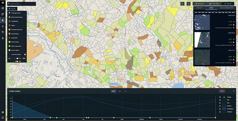
EOS Crop Monitoring allows its partners to extract valuable insights from remote sensing data, e.g., crop types classification maps, crop yield forecasts, field boundaries, vegetation indices, crop conditions, soil moisture and weather data on a field, regional or country scale. EOS Crop Monitoring can be licensed as a White-Label product; thereby, providing EOS partners with platform-based services for their own customers/users to increase interaction between all members of the agricultural value chain.
EOS developed a multi-level deep learning architecture that targets land cover and classifies crop types from multi-temporal, multi-source satellite imagery. The key element of the architecture is an unsupervised neural network that is used for optical imagery segmentation and missing data restoration.
This tool is empowered by EOS EngineTM. Designed as a Platform-as-a-Service (PaaS), EOS EngineTM is massively scalable. It is able to support many types of earth observation data sets and capable of on-the-fly analytics processing system. EOS EngineTM can automatically remove cloud cover and shadows as well as extract valuable information on a different scales with the processing of large-area data.
EOS Crop Monitoring is a tool that includes both historical and current observations. This allows quick identification of a field’s performance throughout the growing season as well as high-risk areas affected by droughts, floods, hail, etc.
EOS Crop Monitoring features include reliable algorithms for more accurate agriculture statistics estimation, crop yield prediction, a seasonal overview of current and historic crop conditions to manage risks and evaluate crop performance.
With an extensive global satellite imagery database, EOS’ data analytics provides its partners with new, expanded capabilities, such as the ability to monitor crop production rates in any crop zone at any given time in both numerical and imagery formats.
EOS allows its partners to expand their own applications through a flexible and scalable API to increase operational efficiency, manage risk, and provide substantiated validation. Through the development of its proprietary, data agnostic platform, EOS can deliver images from a variety of satellites to secure near real-time updates within a field or country level applying state-of-the-art performance and industry-leading services.
EOS’ solutions are successfully verified in North America, Europe, and CIS and are currently being developed in ASIA, MENA and South America by applying its own cutting-edge methods and algorithms.
Explore EOS EngineTM and EOS Crop Monitoring solutions at the website https://eos.com