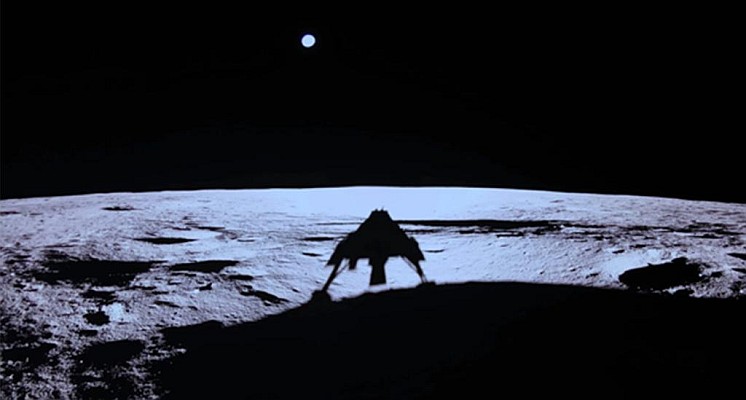
A GNSS receiver has successfully tracked Galileo and GPS signals and computed on board the Navigation Solution during lunar orbit and on the Moon’s surface. This mission proved that Global Navigation Satellite System (GNSS) signals can be acquired, tracked and even used for positioning on the Moon!
In a groundbreaking experiment, the Lunar GNSS Receiver Experiment (LuGRE) has successfully acquired and tracked Galileo and GPS signals, during the BlueGhost 1 lander’s transit on the lunar surface. This achievement in space navigation sets new records for space-based GNSS tracking and positioning.
Historic GNSS tracking and positioning from 0.4 million kilometres!
The LuGRE receiver locked onto Galileo and GPS signals and determined its position in real time using a terrestrial satellite navigation system, from approximately 0.4 million kilometres in the E1/L1 and E5/L5 frequency bands.
The mission was launched from Kennedy Space Center on 15 January 2025 and lasted for two months. It culminated in a smooth landing in Mare Crisium on March 2. The receiver was activated and captured its first signals on March 3, successfully acquiring and tracking four satellites (two GPS and two Galileo) and computing the first-ever GNSS position at the Moon’s surface.
A special GNSS receiver
The GNSS receiver architecture is based on a dual cold redundant configuration of Qascom LEO GNSS Space receiver. The antenna is a high-gain directive one (peak gain up to 15 dB). From the software point of view, the receiver integrates high-sensitivity acquisition and tracking processing, and a custom Navigation Engine. The Galileo Antenna Pattern
was used for the modelling of the scenarios in the Radio Frequency Constellation Simulator (RFCS) and the computation of Link Budget.
Crucially, the Galileo Service Centre (GSC) played a key role in enabling successful operations: ephemeris data from the Time & Geodetic Validation Facility (TGVF-X) were uplinked to the LuGRE payload for acquisition aiding.
Throughout the mission, the status of the Galileo satellite constellation was continuously monitored using official information provided by the Galileo Service Centre (GSC) on its website.
Benefits for all the Space and GNSS community
All the receiver telemetry data collected during the mission will be released to the public domain before the end of 2025 for third-party analysis, research, and other purposes. This will bring concrete advantages to mission design, scientific analysis, navigation algorithm design and GNSS receiver manufacturers.
In addition, specific performance analyses of the Galileo signals (L1/L5) acquired in transfer orbit, in cislunar orbit and at the Moon’s surfacewill be officially published by Science Teams of NASA and the Italian Space Agency (ASI).
Samuele Fantinato from Qascom, states, “We have achieved a GNSS receiver technology proven (TRL9) in space and in Lunar Orbit/Surface. Qascom, as part of the Moonlight programme of ESA (under Telespazio Contract), has the responsibility for the Navigation User terminal that will be used to validate the Moonlight/LCNS navigation services for rovers, landers and Moon spacecraft. There will be hundreds of commercial & governmental missions going to the Moon in the next decade”.
In summary, this experimental mission has proven that GNSS, combined with future Lunar PNT services, can effectively support the first phases of Lunar Exploration.
The LuGRE receiver was developed by Qascom for ASI, in partnership with NASA and supported by the Polytechnic University of Turin.
Carried as one of ten payloads on Firefly Aerospace’s Blue Ghost 1 lander, the receiver was part of NASA’s Commercial Lunar Payload Services (CLPS) programme, highlighting the power of international cooperation in space.
Source: EUSPA
MundoGEO organizes the DroneShow, MundoGEO Connect, SpaceBR Show and Expo eVTOL exhibitions annually in São Paulo, Brazil. See the highlights of the latest edition: