


The methods that had long been proven effective in location-based work: spatial data, its analysis, and visualization on a map-proved to be crucial in an industry that required precision, repeatability, and large-scale operations. The agricultural insurance market was looking for a way to handle claims more quickly, accurately, and consistently.
At the intersection of these two worlds, a solution was developed: reports for specific types of damage, a web application for requesting and retrieving results, a mobile app for fieldwork, and services to support the location and verification of parcels.
How? By understanding the processes, changing how data is collected, and creating services tailored to specific types of damage. So that we can become a partner to the industry in providing efficient and high-quality claims settlement, rather than just a one-time service provider.
Addressing the problem before damage occurs
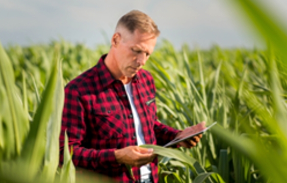
In agricultural insurance, a great deal depends on the data collected at the outset. If the information about the crop’s location is imprecise, it is difficult to prepare the necessary materials for a decision.
Added to this is the scale of the phenomena. Some of the damage covers large areas and results in many simultaneous claims. Others are local in nature and require precision – a difference of just a few kilometres can completely change the picture. The industry must act both quickly and precisely and treat similar cases consistently.
In practice, this means that data must be clearly linked to a specific location in order for further analysis to have real operational value.
From parcel number to an actual view of the field
Combining parcel data with remote sensing analysis proved to be crucial, as it allowed for a shift from formal records to a visual representation of actual crop conditions, enabling an assessment of the situation not only based on parcel numbers but also on field layout, crop type, and the extent of the damage.
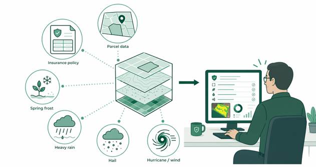
Based on this, reports were prepared for specific types of damage: spring frosts, hurricanes and torrential rain; an assessment of rapeseed density – important in the context of poor overwintering; as well as determining the harvest date to combat insurance fraud. All of this supports the customer at various stages of the process: before a field visit, during incident verification, when assessing the extent of damage, or when documenting decisions.
A report instead of raw data
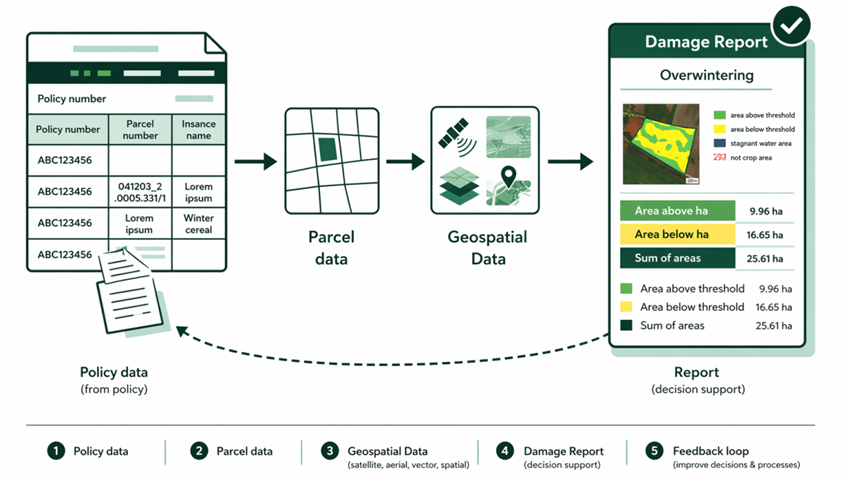
In this process, value is created when, instead of mere indicators or general satellite data, the client receives a finished product that supports the decision-making process by precisely answering a series of questions: Could the phenomenon have occurred at this location? Was the crop in the field during the declared period? What was the actual extent of the damage? Where should field inspections be conducted, and where is the situation already sufficiently clear?
Depending on the type of damage, the report may combine data on plot locations, crop coverage, satellite imagery, meteorological data, and visual materials to aid in assessing the situation.
These are complemented by system solutions: a web application for ordering analyses and downloading results, a mapping application for displaying plots and analysis results, and a mobile application to support fieldwork.
Not everything that is technologically possible makes operational sense
The most valuable features were those that organized work and made decision-making easier. Where simplifications had previously prevailed, detailed information has now emerged: actual location, extent of cultivation, attribution of the phenomenon to a specific site, visual material, and comparable evaluation criteria.
Improving the quality of the input data was the first key step. Second, it makes it easier to compare similar cases and ensures a consistent approach when there are a larger number of reports. Third, practical support for field operations, damage assessments, and decision-making.
This case demonstrates that the ability to apply one’s expertise to solve problems in a specific industry determines whether the result is a one-time implementation or a sustainable business.
InsLAB by the Numbers
- 80% of the domestic agricultural insurance Polish market
- 5 types of agricultural damage
- more than 80,000 reports in 2025
- 322 714 km² – damage liquidation throughout Poland
- 33.8% reduction in field operations during claims settlement
Customer testimonial: „For us, this is not merely a partnership with a service provider. This is a collaboration with a partner who helped us identify gaps in our processes, organize our data, and pinpoint areas for growth that we hadn’t explicitly identified internally before. The impact of this collaboration went beyond simply resolving claims – it had a tangible effect on the development of our services and the way we work.”
OPEGIEKA is a Polish company operating in the GEO/ICT market since 1989, delivering both business and scientific projects for clients across Poland, Europe, and the United States. The company holds the status of a Research and Development Center (CBR) granted by the Minister of Economy, as well as first-level industrial security clearance, enabling it to handle classified information up to SECRET, EU SECRET, and NATO SECRET levels. It is also certified under ISO 9001 and ISO 27000 standards.
OPEGIEKA provides a comprehensive range of geospatial services, including the acquisition and processing of spatial data, the development of dedicated IT systems, and the delivery and maintenance of end-user solutions. The company operates its own Tier III Data Center under the DC4B.PL brand, supporting cloud services and machine learning technologies.
With its own fleet of aircraft, drones, LiDAR remote sensing systems, and large-, medium-, and thermal-format aerial cameras, OPEGIEKA is equipped for advanced data collection. Its in-house IT department develops sophisticated systems using both commercial and open-source technologies, including GIS, ETL, and Big Data solutions.
For more information on how spatial data can support specific business processes and translate into specific solutions contact karolina.wawrzusiszyn@opegieka.pl , Product Owner Agricultural Insurance & Geospatial Solutions at OPEGIEKA or jakub.krawczyk@opegieka.pl Head of R&D and Remote Sensing at OPEGIEKA
Find more: www.opegieka.plMeet us at DroneShow Robotics, MundoGEO Connect, SpaceBR Show and Expo eVTOL 2026 exhibitions, booth 1241
OPEGIEKA, part of the Dephos Group consortium, is confirmed as an exhibitor at the DroneShow, MundoGEO Connect, SpaceBR Show, and Expo eVTOL 2026 trade show, which will be held from June 16th to 18th at Expo Center Norte – Blue Pavilion, in São Paulo (SP).
Check out the schedule of courses, seminars, and forums at DroneShow Robotics, MundoGEO Connect, SpaceBR Show, and Expo eVTOL. Registration is available in advance with a discount, and spaces are limited.
See the highlights from the last edition: