LAND INFO Worldwide Mapping LLC has been named to the 2019 Inc. 5000 list of fastest-growing private companies in the United States.
The firm credits its explosive three-year revenue growth to recent contract wins supporting 5G wireless network mapping.
“We are honored to join a very select group of geospatial companies to make the Inc. 5000 list”
said LAND INFO president Nick Hubing
The 2019 Inc. 5000 companies are ranked according to percentage revenue growth when comparing 2015 and 2018, according to Inc. magazine.
“The companies on this year’s Inc. 5000 have followed so many different paths to success,”. “There’s no single course you can follow or investment you can take that will guarantee this kind of spectacular growth. But what they have in common is persistence and seizing opportunities”
says Inc. editor in chief James Ledbetter
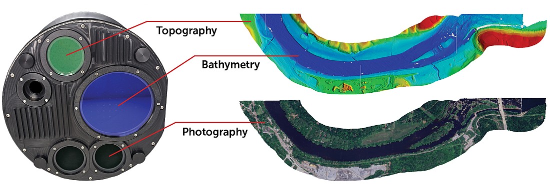
Established in 1993, LAND INFO provides geodata solutions for diverse industries worldwide, including oil and gas, electric utilities, government, visualization/simulation, NGOs, academia, and autonomous vehicle navigation. The Colorado firm began creating map data sets derived from remotely sensed imagery to support global wireless communications projects for over 20 years.
“LAND INFO’s revenue growth has been driven by multi-year investments in proprietary automated mapping technologies, including object-based image analysis and artificial intelligence, which have positioned us to support the demanding needs of 5G wireless network design”.
said Hubing
In the rapidly emerging 5G wireless market where satellite imagery is typically used for map creation, LAND INFO differentiates itself from other mapping firms by using proprietary techniques to quickly extract scalable elevation and landcover information from very high-resolution aerial imagery. The signal propagation characteristics of 5G cell design require a level of detail and accuracy— especially vertical obstacle height data – that is best met with airborne data.
“We appreciate the ongoing support of our many business partners in both the satellite and airborne imaging sectors of the geospatial industry,”. “At the same time, we take pride in our ability to use the source data that best meets the client’s needs for any given project”
said Hubing
Complete results of the Inc. 5000, including company profiles and an interactive database that can be sorted by industry, region, and other criteria, can be found at www.inc.com/inc5000.
DroneShow and MundoGEO Connect 2019
The DroneShow 5th edition and MundoGEO Connect 9th edition 2019 gathered more than 240 hours of content, 110 brands in the fair and 3.800 attendees from June 25th to 27th in Frei Caneca Exhibition Center in São Paulo (SP), presenting as the main topic Drones and Geospatial technologies in the 4.0 Industry: