
senseFly, the global leader in fixed-wing mapping drones, today announces the launch of eBee Ag, the latest addition to the eBee X series of drone solutions. User-friendly and affordable, eBee Ag helps farmers, agronomists and service providers efficiently capture aerial data and plant health insights for faster agronomic decision-making that can improve crop yields and profit potential.
“The agriculture industry has been lacking a viable mapping solution that offers professional results at a more accessible price,” explains Michael O’Sullivan, senseFly Head of Marketing. “The launch of the eBee Ag introduces an affordable fixed-wing solution that delivers the long flight times, range and efficiency—as well as the data quality, accuracy and resolution—that agriculture mapping projects require.”
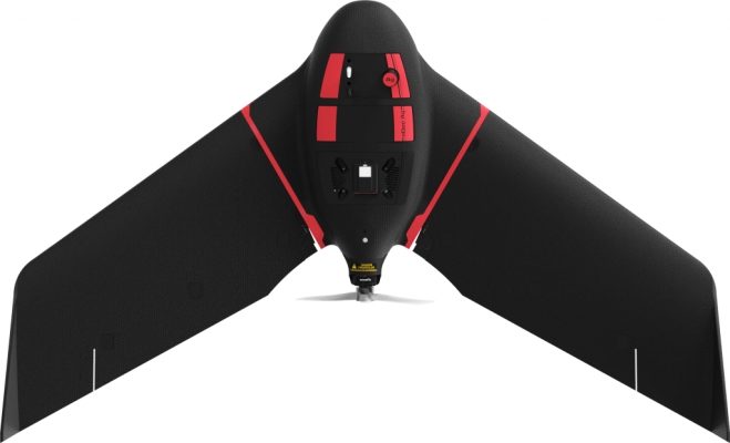
Based on senseFly’s flagship eBee X drone, eBee Ag helps agriculture professionals overcome the many challenges they face in the field related to planning, plant health and crop monitoring. eBee Ag makes it easier than ever to field scout, ground-truth potential problem areas and gain critical crop health and field information.
eBee Ag is suited for intensive and repeated crop mapping missions. Equipped with its standard battery, it is capable of up to 45-minutes of flight. An endurance battery increases flight times to up to 55 minutes—allowing eBee Ag to cover more than 160 hectares (395 acres) in a single flight and saving precious time and money when compared with conventional scouting.
eBee Ag features senseFly’s new, lightweight Duet M dual-sensor fixed payload, which comprises the senseFly S.O.D.A. RGB and Parrot Sequoia+ multispectral cameras. With its dual-purpose camera, eBee Ag captures accurate RGB and multispectral data from the sky to help make better decisions on the ground. Regularly collecting multispectral data is critical to effectively assess crop health, optimize inputs and catch early indicators of pests, diseases and weed infestations that threaten crop yields. Highly-accurate index maps allow agriculture professionals to understand each acre while managing problematic areas field-wide – before they impact profits.
eBee Ag also features available Real-Time Kinematic (RTK) functionality for greater mapping precision. With its available RTK, eBee Ag can achieve absolute accuracy down to 2.5 cm (1 in) with RGB. This position data can then integrate seamlessly into existing GPS-enabled machinery and/or Farm Management Systems.
eBee
Ag also comes with senseFly’s new eBee X series backpack, which is
a smart and durable way to carry everything needed to transport the
drone into and out of the field.
The eBee Ag shares its DNA with senseFly’s flagship eBee X fixed-wing mapping drone, which revolutionized the unmanned aerial vehicle sector with its ease-of-use and multiple, state-of-the-art sensors. With a unique Endurance Extension option enabling a flight time of up to 90 minutes and single-flight coverage of up to 500 ha at 122m (1,236 acat 400 ft.), the eBee X is a premium solution that offers users the high-precision of on-demand RTK/PPK for achieving absolute accuracy of down to 1.5 cm (0.6 in) – without ground control points.
Farmers, agronomists and other agriculture professionals—including enterprise organizations, who purchase eBee Ag or any drone from the eBee X line—get access to senseFly’s intuitive eMotion flight planning software, technical support and resource offerings, including its in-house team of experts, global distribution network and the newly launched senseFly Academy e-Learning Training Platform and Certified Operator Program.
For more information on the new eBee Ag fixed-wing solution and the rest of the eBee X series, please visit www.sensefly.com.


