

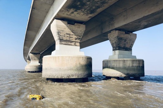
The Donghai Bridge, located in Shanghai, China, is a key component of the Shanghai International Shipping Center’s deepwater port infrastructure.
Conducting underwater surveys of the bridge piers’ conditions for maintenance purposes is an operational challenge. The bottom of the bridge piers is immersed in water and can be eroded by the action of sand and gravel. Hydrodynamic scour caused by rapid water flow can create scour holes and compromise the integrity of the structure.
To determine whether piers need to be protected by additional riprap, the precise sediment scour conditions need to be investigated, but this poses operational challenges for traditional 3D bathymetric surveys.
CHCNAV Apache 6 unmanned survey vessel, carrying a NORBIT iWBMS STX multibeam echosounder was selected for the bridge survey project. Integrated with new technologies, Apache 6 has the capabilities to complete the absolute straight-line course, water flows adaptive propulsion, stationary hovering, shoal reversing, and inertial navigation, expanding the application scenarios.
There are three points to be concerned when conducting bathymetric survey with an UAV: How secure is their investment given the cost of multibeam echosounder? Does the USV offer sufficient flexibility to handle a variety of bathymetric survey scenarios? What about the final accuracy of the high-resolution 3D bathymetric survey?