TOPODRONE, a Swiss based designer and manufacturer of high-precision surveying equipment, has synchronized airborne photogrammetry, and LiDAR and bathymetric surveying methods which was used to study a floating solar farm. The synchronization was performed upon a request from the Israeli drone service provider ERELIS to conduct a pilot project of reservoir surveying with a UAV for ETZ HADEKEL Ltd. in Northern Israel. The surface of the reservoir is covered by solar panels, which made it difficult to carry out work using standard methods of surveying from a boat.
ERELIS performed two-stage drone surveying to deliver a high-precision 3D model of the reservoir. First, aerial photogrammetry and LiDAR surveys were performed using a DJI M300 drone equipped with a TOPODRONE camera P61 and a LiDAR HI-RES system to determine the location of possible obstacles. LiDAR scanning provided accurate detection of cables in the water.
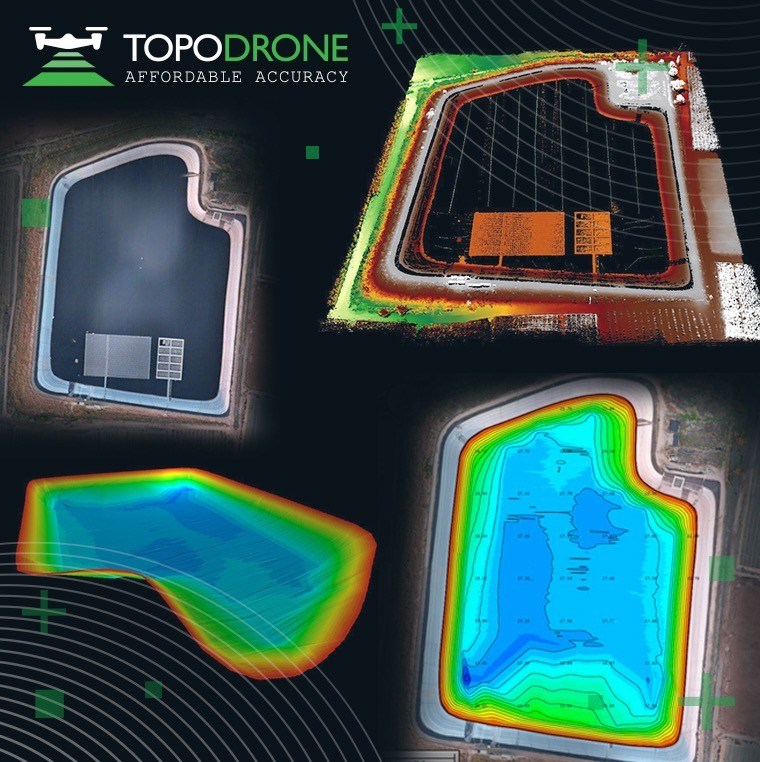
Second, an underwater bathymetric survey using a TOPODRONE AQUAMAPPER mounted to the same drone was conducted avoiding detected obstacles (cables, solar panels and other objects). The flight mission was planned and executed with the UgCS software by SPH Engineering.
The collected LiDAR & bathymetry data was processed by TOPODRONE Post Processing software. As a result, a georeferenced orthophoto map, a 3D model of the relief and objects, a 3D model of the bottom of the reservoir, contour lines and isobaths were generated. Such 3D models can be used for high-precision assessment of sediment volumes, general monitoring of reservoir banks and visual monitoring. In addition, surveying with a TOPODRONE AQUAMAPPER made it possible to estimate sludge deposits of the reservoir.
“Our company has been performing drone-based bathymetric surveying services for water reservoirs/basins and coastal waters since 2021. The unique ability to use the same UAV (DJI M300) with different kinds of TOPODRONE equipment, LiDAR HI-RES systems, a high resolution camera and AQUAMAPPER, makes it possible to unify equipment use, thereby reducing costs and eliminating the need for additional tools. The aerial and echo-sounding data synchronization at the post-processing stage helps to obtain the full geo-data package that could be used for survey and data digitization, modeling, mapping, aerial photogrammetry, quantities calculation or other output products by client demand,” commented Roman Kirsanov, CEO of ERELIS.
“Back in autumn 2022 we had our first AQUAMAPPER client that used the device together with TOPODRONE LiDAR ULTRA for an EU road construction project to build a highway in one of the toughest terrains with a river component in Romania, EU. We are proud to see clients developing new application areas of our equipment, including reservoir characterization and modeling,” added Maxim Baklykov, CEO of TOPODRONE.
To learn more about TOPODRONE LiDAR and bathymetric solutions to perform reservoir characterization and modeling join a free online webinar on January 26, 2023.
To learn more about a bathymetry survey of a floating farm performed by ERELIS Group with TOPODRONE AQUAMAPPER watch the video: