Drones and Robotics
Space
eVTOL
Geointelligence
Newsletter
WhatsApp
Exhibitions
DroneShow Robotics
MundoGEO Connect
SpaceBR Show
Expo eVTOL
Exhibitors
Lives
Videos
Webinars
About Us
Social Networks
Exhibitors
images
Geointelligence
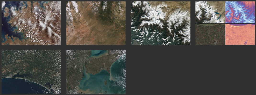
NASA, USGS Release First Landsat 9 Images
News
FalconScan announces the release of its Ground-Breaking Aerial Mapping System
News
Mobile Ground Penetrating Radar (MGPR)
News
OGC announces KML 2.2 Test Suite
Drones and Robotics
University of Belize launches drone for GIS monitoring
News
SuperGIS Server JavaScript API sample provides developers
News
SimActive releases Correlator3D version 5.0
News
GMV wins a cartographic production contract from the Emirate of Abu Dhabi
News
UAV captures aerial images of Easter Island Volcano
News
SuperGIS Server 3.1a standard edition to support mobile SDK
News
Optech acquires Geospatial Systems
News
The Italian satellite COSMO-SkyMed 4 reaches its final orbit
Editorials
Drones and Robotics
eVTOL
Geointelligence
Space
Live Schedule
02 June 2026 - 15h00
Desenvolvimento do ecossistema de eVTOLs: o ponto de vista das autoridades aeronáuticas
26 May 2026 - 11h00
Além do voo – geotecnologias em foco
Video
2025 Feira/Exhibition MundoGEO Connect | DroneShow Robotics | SpaceBR Show | Expo eVTOL
Sign up for our newsletter
Enter your email
Invalid Email
Calm down, we will not share with any third parties.
Confirm Subscription