
Ideal for Precision Farming Applications
The Red Edge band data from multispectral earth observation satellites gives agricultural customers the ability to pinpoint subtle stress in crops before the condition is detectable with traditional vegetative indices or the naked eye. This information enables growers to assess the root cause of the problem and take remedial action before the ailment spreads or plants are lost.
The most common causes of plant stress are poor irrigation, inadequate nitrogen fertilization, disease, and pest infestation. Any of these problems can result in lower chlorophyll production in green plants. For decades, multispectral imagery has been relied upon to identify these crop health issues, primarily by combining visible red and near-infrared band data in formulas referred to as vegetative indices. In addition to revealing plant stress related to chlorophyll content, these indices can estimate biomass and canopy density.
Governmental organizations have long relied on coarse-resolution from Sentinel-2 or Landsat data to assess vegetative health and predict harvests in large regions as a crucial aspect of ensuring food security. More recently, with the advent of higher-resolution data sets, growers began calculating indices on a more granular level to assess crop conditions and implement precision farming practices in individual fields.
The addition of red edge data considerably enhances these vegetative indices and their applications by enabling users to detect anomalous crop health earlier in the growth cycle. For even a small farmer, this means there is more time to diagnose the issue, apply a remedy, and save the harvest. At a regional and national level, this can give government agencies advance notice of an impending crop failure preventing widespread societal consequences.
The Red Edge Difference
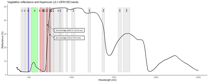
The Red Edge band roughly spans 670-760 nanometers, placing it between the visible red and near-infrared bands on the electromagnetic spectrum. The red edge is the region of the spectrum where the spectral reflectance of green vegetation changes rapidly. Vegetative stress will show itself here first. This is explained by the strong amplitude on the reflectance of energy in the red edge wavelength by chlorophyll from green to unhealthy vegetation. A healthy plant has more chlorophyll and reflects more light energy in the 670-760 nm sliver of the spectrum. Higher reflectance means a higher spectral value in this wavelength. Stressed vegetation reflects less than healthy plants of the same species in the red edge.
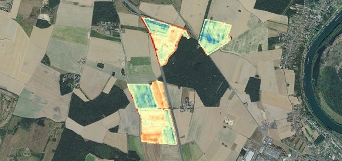
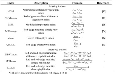
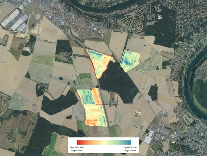
The spectral signature in the red edge is an excellent indicator of vegetative health. Agronomists, botanists, and other scientists who have traditionally assessed plant vigor and biomass density with three common vegetative indices are replacing visible red band values with red edge reflectance numbers in the formulas. Enhanced with the red edge, the most widely used indices as the Normalized Difference Vegetation Index (NDVI), the Modified Simple Ratio index (MSR), and the Green Chlorophyll (CIgreen) (Figure 2) are now detecting changes in chlorophyll and nitrogen content earlier than previously possible. Inclusion of the Red Edge in these indices improves both the accuracy of the crop [condition] classification (Figure 3) and the differentiation of plant species.
HEAD HyperScan satellite improves the data acquired in the Red Edge
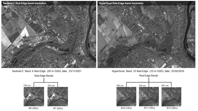
HEAD HyperScan (JL1-GP01/02) are two satellites that acquire images with a different spatial resolution (from 5 m to 150 m) in a total of 26 spectral bands. Its swath covers 110 km width, and they have a 2-day revisit capacity to take imagery for the same target. Its configuration improves the resolutions of the data acquired by the Sentinel-2 satellite, offering double resolution in the red-edge bands. HEAD HyperScan satellites capture red edge since 2019 at medium resolution in three separate bands (Figure 4).
The following table (see Figure 5) shows the different bands that make up the HyperScan images, their main applications, the spectral region where they are focused, and their spatial resolution. It also serves to compare the aforementioned characteristics against Sentinel-2. It can be concluded that both spectral resolution and spatial resolution are better in HyperScan as we have double number of bands (26) and the double spatial resolution (up to 5 m GSD).

SuperView-2 (0.4m GSD), NightVision & Video Constellation (0.92m GSD), and NatureEye (2m GSD) are three more EO satellites in the HEAD portfolio that provide the red edge bands. These sensors have different resolutions, which are sufficient to monitor individual fields or expansive growing regions. For example, the stress in a single fruit tree, and perhaps some individual row crops, can be identified with very high-resolution data from the HEAD SuperView-2 satellite. Assessment of issues affecting entire farm fields or even large geographic regions is possible with moderate and coarse resolution imagery captured over wide swaths of land by the NightVision, NatureEye, and HyperScan constellations. These satellites archives are searchable using the HEADFinder platform.
Just as important, the applications of red edge data are not limited to agriculture. Foresters, for example, can use the data in similar ways as farmers to spot disease or infestation in tree stands. Also, environmentalists are experimenting with the data to study water quality in lakes and streams using the presence of chlorophyll-bearing phytoplankton as a gauge of health in aquatic ecosystems.
About HEAD
HEAD Aerospace (HEAD), founded in 2007, is a privately-owned space company with its headquarter in Beijing. HEAD has an extended presence globally, including subsidiaries in Hong Kong, France, and the Netherlands.
Thanks to the +45 Earth Observation satellites, HEAD is uniquely positioned to be a key player in the geospatial market and act as a prime contractor to provide complex turnkey integrated geospatial solutions. The international team manages more than 110 distributors worldwide to market satellite imagery collected by Chinese commercial and government satellites. Our offer includes a direct receiving station for near real-time access to satellite imagery, a centralized geodata hub of satellite imagery, and processing geospatial data for government and commercial users.
About Alexandre Wiefels*
Remote Sensing Project Manager
HEAD Aerospace Group, France
alexandrewiefels@head-aerospace.fr
Alexandre
Wiefels is the Remote Sensing Technical Manager at HEAD Aerospace Group,
France, and is in charge of managing technical projects. Based at the Paris
office, he provides technical support to projects and oversees the image
processing team, the image quality control of remote sensing products, and
managing the HEADFinder ordering platform. Alexandre comes from a scientific
background with his master’s degree from the Brazilian National Institute of
Space Research (INPE) and the University of Reunion Island (France), a Ph.D. in
the University of Montpellier (France), and two postdocs at the University of
Reunion Island, all in remote sensing applications. Alexandre originally comes
from Brazil, he is native speaking in Portuguese and French, bilingual in
Spanish and English.
About Carlos Baroja**
Remote Sensing Project Manager
HEAD Aerospace Group, France
carlosbaroja@head-aerospace.fr
Carlos Baroja is a Remote Sensing Project Manager based at the Paris office, and in charge of providing technical presale support of all the ordering to the Sales team and oversees the image quality control of remote sensing products and managing the taskings. Working closely with our reseller team, Carlos provides technical support and training on HEAD products, and he is responsible for feasibility studies and managing projects with our partners. He has experience working as a Remote Sensing technician at the National Geographic Institute of Spain (IGN), coordinating the activities of the National Remote Sensing Plan and designing training content for the users, as well as experience as a GIS technician at Pyrenean Institute of Ecology (CSIC). Carlos holds a
bachelor in Geography and Land Management and a master’s degree in GIS &
Remote Sensing from the University of Zaragoza (Spain). He speaks native
Spanish, and he is bilingual in English.