
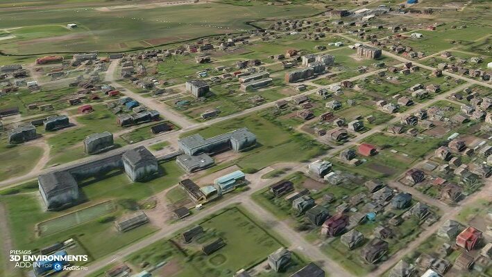
Presagis, a global leader in 3D advanced modelling and simulation software, is releasing the 3D Environments Add-In application for Esri’s ArcGIS Pro. 3D Environments allows ArcGIS users to rapidly transform 3D Tiles Next data formats, such as One World Terrain, into ArcGIS Pro projects to create 3D scenes from 2D vector data and 3D models.
Available on the Esri ArcGIS Marketplace at the end of June, the 3D Environments Add-In leverages Presagis’ building templates and texture libraries that analysts can use to create enhanced 3D visualizations of GIS environments, thus helping increase collaboration across the enterprise. The Presagis 3D Environments Add-In contains tools to create, transform, and extract a wide variety of 3D formats to provide seamless interoperability between ArcGIS Pro and modeling & simulation applications.
“The 3D Environments Add-In is the result of the close relationship we have built with Esri. We are excited to bring our modelling and simulation expertise to the Esri Marketplace and the ArcGIS community,” said Jean-Michel Briere, President of Presagis, “the convergence of GIS data and simulation is critical to create accurate and realistic digital twins – and Presagis can help lead the way.”
“The Presagis 3D Environments Add-in for ArcGIS Pro extends 3D workflow interoperability between ArcGIS and ModSim 3D data formats such as CDB,” said Jamon Johnson, Product Leader for the Esri 3D Core Team. “Analysts can now fully integrate CDB into their ArcGIS Pro projects as well as leverage OpenFlight Models into 3D visualization applications.”
The ability to create and implement detailed and realistic 3D content in ArcGIS Pro is available now. To learn more and sign up for a 30-day free trial, please visit: www.presagis.com/en/product/3denvironments-addin.


