
Planet Labs, a leading provider of daily data and insights about Earth, and NASA Harvest, the federal space agency’s Global Food Security and Agriculture Program, announced a partnership to further support the joint Food Security and Agricultural Monitoring Solution. The offering aims to deliver policy-grade agricultural monitoring and assessments of potential threats to global food security.
The offering will combine Planet’s satellite data and other publicly-available datasets with the analytics expertise of the combined NASA Harvest team, facilitated by the University of Maryland and University of Strasbourg – creating an assessment tool that could play a key role in anticipating and averting food shortages and famines.
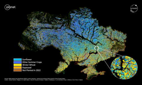
This work was first piloted to monitor fields in Ukraine in 2022 to track frontline agricultural activity and assess the impact of war on crop production. Replicating that process, and building on existing NASA Harvest expertise in the public sector and Planet’s commercial offerings, the work is now being scaled to conduct regional and global assessments. The solution will be offered to national governments, multilateral institutions, NGOs and other interested parties around the world.
“The world’s food security is at a moment of enormous uncertainty – triggered not only by the war in Ukraine, but by many other serious challenges, especially those linked to climate,” said Andrew Zolli, Planet’s Chief Impact Officer. “From drought in Somalia to flooding in Pakistan, the combination of real-time satellite imagery and sophisticated analytics can illuminate many types of risks to our global food systems, helping us adapt agricultural practices, adjust global supply chains, and mitigate risks to poor and vulnerable communities.”
For decades, the NASA Harvest team has been developing innovative satellite-based techniques to monitor commodity crops such as wheat, maize, soybeans and rice. The team also collects and analyzes environmental, economic and social science data to create a full picture of the pending food landscape.
“Planet’s data was able to help us create a field-by-field analysis of what was planted, what was harvested and what was disrupted, which has been critical to understanding what is happening in Europe’s breadbasket,” said Inbal Becker-Reshef, Program Director for NASA Harvest, referring to the pilot project, further adding that “this effort plays a key role in NASA Harvest’s broader initiative to provide rapid agricultural assessments for policy support in the face of food security and market threats.”
“This level of understanding can greatly benefit other organizations to monitor and predict potential issues in their own regions, moving us from research to impact,” Becker-Reshef continued. “It was important to both of our organizations that we make these analyses more broadly accessible in order to improve agriculture-related decision-making around the world, leveraging the unmatched high spatial and temporal resolution that Planet data offers.”
While this marks the first commercial relationship between Planet and NASA Harvest, the pair has a well-established history of impact- and science-related initiatives. The collaborations grew out of NASA’s Commercial SmallSat Data Acquisition (CSDA) Program, under which Planet has been providing data to NASA scientists and federally-funded researchers since 2018. For example, Planet and NASA Harvest supported the Government of Togo in its COVID-19-related food security relief efforts by creating a cropland map of the entire country, delivered within 10 days of receiving the request, allowing the government to mobilize quickly to ensure food security during the global pandemic.
For more information about accessing the Food Security and Agricultural Monitoring Solution, please email food-security@planet.com.


