

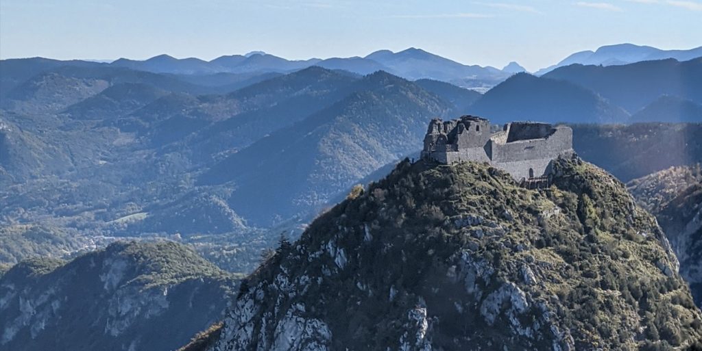
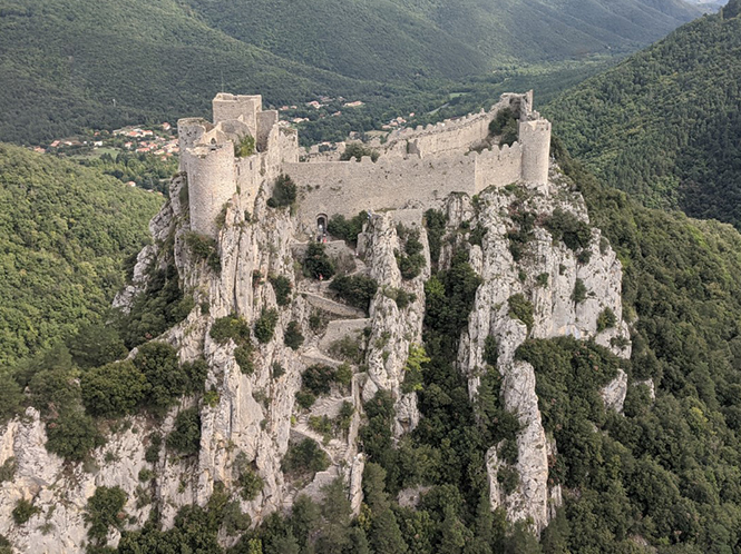
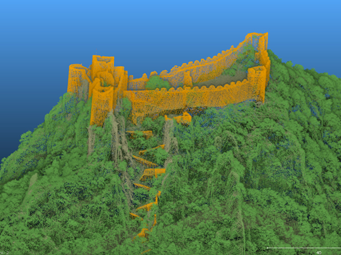
The Association Mission Patrimoine Mondial (AMPM) is an organization created to manage the process for the city of Carcassonne (South of France) and its Sentinel mountain castles better known as “Les Châteaux Cathares”, to successfully obtain UNESCO World Heritage certification. Built in the 13th century, the combined site is an exceptional example of military architecture and construction from the time. As a part of the certification process, they need to provide 3D models that can identify known archaeological remains and possibly detect new ones for future exploration and make sure they are all protected by UNESCO classification. L’Avion Jaune was mandated to fly the mission using the YellowScan Explorer LiDAR solution.
What was the Challenge?
The 7 fortified castles are spread out over 60 kilometers of mountainous terrain and not easily accessible by foot, so traditional archaeologic methods did not make sense for this phase of the project. A secondary objective of the project was to identify any new archaeological sites that were not previously identified and visible to the naked eye for further research as well as survey the primary 7 sites looking for ruins yet to be discovered.
Solution
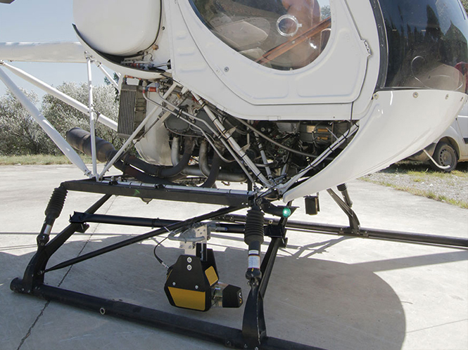
Given the mountainous terrain and distance between the different castles, it was decided that a manned helicopter mission was the best profile to capture not only the photogrammetry resources for the sites, but also the point could data to render the 3D models. The team used the YellowScan Explorer, our first LiDAR solution that can be mounted on a light manned aircraft or helicopter as well as mounted on any professional UAV platform.
Our objective with Explorer, like all of our hardware platforms, is to offer the market a solution that strikes the right balance between size, range, accuracy and weight. Combined with 1-year unlimited technical support and training, our users will be ready to take full advantage of Explorer’s functionality and successfully complete their surveying projects.
Mission Parameters
- 7 castles surveyed
- 5 days of flight
- 3 flights
- 200meters from the ground
- 80 points/m²
- Ground data under canopy
- Using light helicopter and YellowScan Explorer
- 30-35m/s Flight speed
“Due to the difficult access and the density of the vegetation around the castles to be studied, airborne LiDAR was the only feasible option. The Explorer’s long-range capability and size allowed us to easily integrate the solution on the helicopter and survey the 7 castles, which are geographically distant, more quickly than if we had had to do it with a drone. Given the Explorer’s 5 echo capability it can easily penetrate the vegetation to recover the ground and generate the terrain profile, allowing the production of an accurate DTM thus giving the archaeologists a new set of mapping tools for their project.“ Benjamin Pradel – Pilot & Aerial Survey Project Manager, L’Avion Jaune
Results
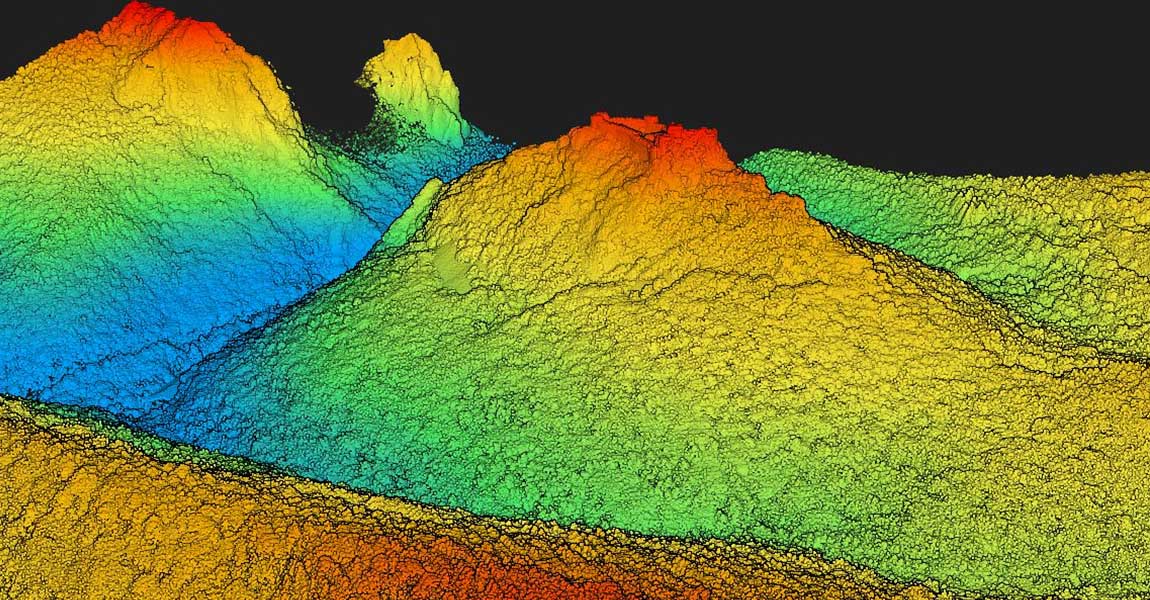
In total, 3 helicopter flights were necessary to map the totality of the castles spread over the departments of Aude and Ariège, in the South of France. The data recovered in fact did detect possible reliefs and ruins suggesting undiscovered human activity which will serve as a guide for future archaeological excavations. The mission also justifies an extension of the original protection zone planned for these historic sites.
By commissioning the complete 3D modeling of the seven sentinel mountain castles, the AMPM has improved its understanding of the historical significance of the area and increased its chances for a successful outcome to its UNESCO World Heritage application.
Key Benefits of the YellowScan Explorer
- YellowScan’s longest range scanner (600m)
- Single solution for multi-platform usability
- Applanix APX-20 IMU
- Can switch between 100 -500 kHC PRF depending on mounted vehicle
- 165Hz scanning frequency
About YellowScan
At YellowScan, we design, develop, and build LiDAR solutions for professionals that require performance, robustness, and accuracy. Our hardware and software solutions are easy-to-use data collection tools that come with training and support from our experts.
Founded in 2012 in the South of France, we now have sales, customer training, and support representatives around the globe. Our products are used worldwide in surveying, forestry, environmental research, archaeology, industrial inspection, civil engineering, mining sectors, and more.
Our products come with embedded laser scanners, INS, GNSS receivers, and onboard computing. Each system is designed to meet the highest precision and accuracy needs for 3D mapping.
Our ecosystem is based on three pillars: the first being our compact turnkey hardware with embedded batteries that are designed, built, and supplied ready to operate.
The second is our proprietary software, the YellowScan CloudStation, with its user friendly and evolving interface.
And the third is our committed technical experts that deliver complete training sessions to customers upon receiving their systems, as well as a 1-year unlimited technical support to enable our customers to confidently undertake their projects, whether they are new or experienced in the field.
The best approach to selecting a LiDAR system for crewed or uncrewed aerial applications
The first criteria, when selecting a LiDAR system, would be the accuracy expected. You generally don’t need a 1cm-accuracy when creating a DTM, but you probably will for surveying facades or archaeological monuments.
Then comes the range selection of the main application: trees above 30m high, or 40-storey building? This will impact the flight height for the operations, and therefore will give you a better idea of which of system fits your need. This would also be determined by the platform on which you will mount your LiDAR unit.
Only then will you need to find the best compromise between density and productivity by adapting your flight plan, in terms of speed and overlap.
Our LiDAR systems have been used in many different scenarios, thanks to the trust customers have placed in our products. Our systems are used in archeology, mining, powerline management, avalanche risk detection, rural road monitoring projects and many more.
YellowScan’s CloudStation software for LiDAR pointcloud processing
The CloudStation software is very intuitive, user-friendly and requires just a few clicks to generate the final pointcloud.
Our additional modules can improve the precision of the generated pointcloud, or the interpretation of the area (automated colorization without any tie points to manually select, or ground classification).
We also strive to improve the use of computer resources to minimize the processing time, by optimizing the CloudStation algorithms between releases (every 3 weeks).
Need help selecting a LiDAR solution that best fits your needs? Please get in touch for a proof of concept tailored to your unique requirements.