

Across Latin America, the demand for reliable geospatial data is increasing as cities expand, infrastructure networks modernize, and mining, energy, and construction projects move into more complex environments. The region’s infrastructure needs remain substantial. The IDB estimates that Latin America and the Caribbean need to invest at least 3.1% of regional GDP each year through 2030 to expand and maintain infrastructure aligned with development goals.
For surveyors and engineering teams, this broader challenge becomes very practical in the field. Work is rarely limited to open-sky conditions. Crews often operate along highways, urban corridors, bridges, dense vegetation, steep terrain, mines, industrial sites, and areas where mobile coverage can be inconsistent. In these environments, traditional GNSS RTK receivers can deliver excellent results when satellite visibility is clear, but performance may degrade quickly when GNSS signals are blocked, reflected, or completely lost.
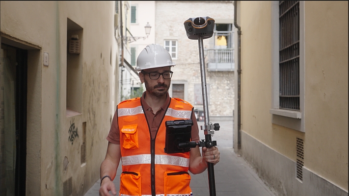
This is the gap the CHCNAV ViLi i100 Vision-LiDAR GNSS RTK receiver is designed to address. It combines GNSS, high-frequency IMU, multi-camera vision, LiDAR, and the SFix 2.0 engine to help maintain reliable accuracy where conventional GNSS workflows often slow down or stop.
Accuracy When the Environment Is Not Ideal
Traditional GNSS RTK depends heavily on satellite visibility. In open areas, this is rarely a problem. In real project environments, especially in dense cities or infrastructure corridors, the situation is different. Buildings, bridges, retaining walls, vegetation, and machinery can create obstructions and multipath effects, reducing positioning stability and forcing crews to repeat measurements or change methods.
The ViLi i100’s multi-sensor fusion filters GNSS signals affected by blockage or reflection and maintains stable, jump-free 5 cm accuracy in challenging environments such as alleys, forests, and areas near high-rise buildings. In these cases, the benefit is not only better accuracy. It is the ability to keep collecting data with confidence when conditions change.
Measuring Beyond Satellite Visibility
Many high-value projects do not allow survey teams to work only where GNSS conditions are ideal. Metro construction, bridge inspections, drainage works, port areas, mines, and energy sites often include short but critical sections where satellite visibility is unreliable. In these moments, the productivity gain comes from avoiding a break in the workflow.
With SFix 2.0, the ViLi i100 uses the last reliable GNSS position as a reference, then combines LiDAR and SLAM-based constraints to maintain positioning. The system delivers 5 cm accuracy within 20 meters in GNSS-denied areas, using an 860,000-points-per-second LiDAR scanner and algorithms trained on large real-world datasets.
Safer Non-Contact Measurement
In many field operations, the safest point to measure is not always a point where a person can stand. Surveyors may need to capture facades, embankments, traffic areas, pipelines, structures, slopes, or inaccessible assets. Contact-based measurement can increase exposure to moving vehicles, unstable ground, steep terrain, or industrial hazards.
The ViLi i100’s Vi-LiDAR workflow supports non-contact measurement by allowing users to capture a scene once and extract multiple 3D coordinates in batches. The system can deliver 5 cm accuracy at 15 meters using its 8 MP telephoto camera, without requiring precise aiming or a perfectly steady hand.
Crews can collect points from safer positions, reduce repeated manual operations, and accelerate data capture in areas where access is restricted, hazardous, or inefficient.
Field-Ready Earthwork and Volume Decisions
Earthwork measurement is another area where productivity depends on speed as much as precision. In construction, mining, quarrying, road building, and land development, teams need timely volume information to manage cut-and-fill balance, stockpiles, excavation progress, and contractor reporting.
Paired with CHCNAV LandStar software, the ViLi i100 supports real-time 3D point cloud earthwork calculation. Users can scan, define boundaries, and obtain instant cut-and-fill or volume results on site. This changes the workflow from “collect now, process later” to a more immediate field decision model. For projects where equipment, trucks, operators, and material movement are tightly scheduled, the ability to verify volumes directly on site can help reduce delays and unnecessary rework.
From Multiple Instruments to One Adaptive Workflow
The broader value of the ViLi i100 is not that it replaces every surveying instrument in every scenario. It reduces the number of times survey teams need to stop, switch tools, or change workflows when the environment becomes difficult.
A standard GNSS receiver remains highly productive in open-sky conditions. A total station remains essential for many control and precision tasks. The ViLi i100 is positioned between these workflows, extending GNSS productivity into areas where satellite visibility is obstructed, where short GNSS-denied sections interrupt data collection, or where non-contact measurement can improve safety and speed.
| Feature / Scenario | Typical GNSS Receiver | CHCNAV ViLi i100 |
| Product specifications | IMU-fused GNSS with limited sensor integration | Fully integrated visual, LiDAR, and GNSS system |
| GNSS obstructions | Accuracy may degrade | Stable high accuracy |
| GNSS-denied areas | Generally unusable | 5 cm accuracy within a 20 m radius |
| Pole tilt compensation | Limited support, typically 60°–120° | 360° support, including inverted measurements |
| Contactless measurement | Limited functionality or multiple steps | Optimized, efficient, real-time on-site workflow |
Built for the Reality of Fieldwork
As Latin America continues to invest in infrastructure, urban mobility, mining, energy, and smart cities, geospatial professionals will need adaptable field systems that support safety, speed, and confidence where projects actually happen. By tightly fusing multiple sensor technologies, the CHCNAV ViLi i100 helps surveyors move beyond the traditional limits of GNSS satellite visibility and maintain productivity across a wider range of environments. For engineering firms, survey contractors, land agencies, construction teams, and mining operators, the value lies in collecting reliable data with fewer interruptions, from the first point to the final deliverable.
Discover the schedule of courses, seminars, and forums for DroneShow Robotics, MundoGEO Connect, SpaceBR Show, and Expo eVTOL. Registration is available in advance with a discount, and spaces are limited.
See the highlights from the last edition: