Cornel & Cornel Topoexim S.R.L., a Romanian company based in Bucharest, which will be attending MundoGeo Connect 2026 as a member of the Central European consortium, under the umbrella of the Dephos Group, has extensive experience in surveying, geodesy, photogrammetry, cartography and geographic information systems (GIS), as well as broad experience in managing large-scale interdisciplinary projects.
As one of Romania’s leading companies, it brings significant, relevant and diverse expertise across a wide range of geomatics disciplines, supported by an experienced and technically proficient team.
We present one of our areas of shared expertise: the programme for updating the cartographic data required for the updating, validation and maintenance of aeronautical and airport safety maps in Romania.
Case application: LRBM (Baia Mare / Maramureș) – validating, completing, and reconciling AD 2.10 obstacle records
Introduction
Obstacle data is safety-critical; once published in the AIP, the focus shifts to maintaining trust, consistency, and controlled updates. QC becomes a structured process addressing internal, external, and temporal inconsistencies.
The LRBM AIP provides a standardized obstacle inventory and aerodrome reference data, forming a reliable regulatory baseline for evidence-based validation.
Source Baseline
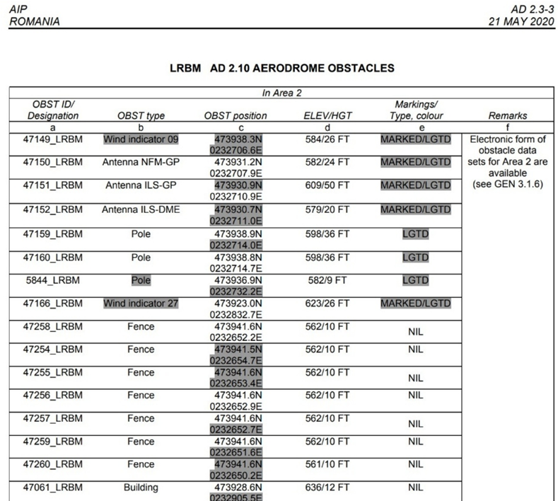
The “LRBM AD 2.10 AERODROME OBSTACLES” table provides structured data on identifiers, type, position, elevation/height, and marking. While authoritative, it lacks details on accuracy, survey methods, and change history. QC should therefore add governance metadata (e.g., accuracy, source, validation status, revision history) while preserving traceability to the AIP baseline.
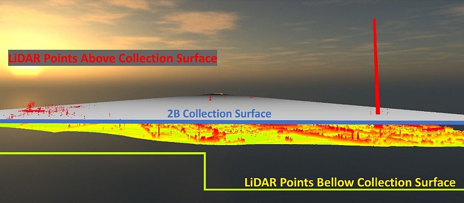
Obstacle Collection Surfaces (OCS)
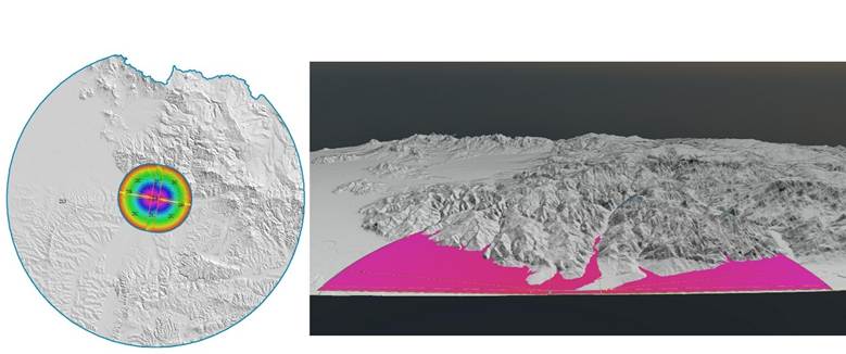
Within the AIP framework, obstacles are assessed against Obstacle Collection Surfaces (OCS), which define the spatial scope for identification, control, and compliance, ensuring required clearance.
In GIS, OCS are modeled as parameter-driven surfaces derived from runway geometry and regulatory criteria, including runway/strip, approach/departure, and lateral surfaces.
For QC, OCS establish both the validation framework and priority: obstacles near or penetrating these surfaces are prioritized based on operational risk.
QC Objectives for an Existing Official Obstacle Database
A quality control program for an existing AIP obstacle dataset must extend beyond basic verification to address the ongoing management of a safety-critical, legally authoritative database. QC becomes a governance process focused on maintaining reliability while enabling controlled improvement, structured around five core objectives.
Integrity ensures the dataset is complete, consistent, and technically valid, including correct coordinate formats, unit consistency, and logical relationships between elevation and height.
Traceability requires that all changes retain clear linkage to the original AIP baseline, with documented sources, rationale, and decision processes.
Reconciliation resolves inconsistencies such as duplicates, conflicting values, or mismatched identifiers, ensuring the dataset functions as a coherent system.
Currency addresses the dynamic nature of obstacles by identifying additions, removals, and modifications through comparison with independent data sources.Safety relevance remains central, with all validated data assessed against Obstacle Collection Surfaces to prioritize risks and evaluate operational impact.
Methodology: An Efficient End-to-End Workflow
Step 1 – Extract and Normalize
AD 2.10 records are structured with preserved identifiers and key attributes. Coordinates are converted to decimal degrees with traceability maintained, and the dataset is stored in a governed schema with QC metadata.
Step 2 – Reference Frame Governance
Coordinates use WGS 84 with controlled transformations. Vertical data follows a defined datum and geoid, preserving feet while computing metric values.
Step 3 – Automated Validation
Schema, coordinate, and unit checks remove errors, while logical and spatial rules detect inconsistencies, duplicates, and misplacements.
Step 4 – Cross-Validation Data is verified against orthomosaics and LiDAR, with surveys used for critical discrepancies near OCS, aligning effort with risk.
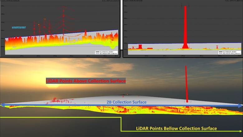
Height residuals (measured − AIP) are stored with confidence classes, guiding acceptance, review, or field verification. Change detection uses orthomosaics/LiDAR for deletions and DSM plus imagery for additions. New candidates are recorded as QC_STATUS = “draft” with identifiers assigned per authority rules.
Step 5 – Reconciliation
Duplicates are consolidated into canonical records with aliases. Conflicts are resolved via a source hierarchy, retaining original and updated values. Obsolete obstacles are marked as retired, and missing attributes are supplemented.
Step 6 – OCS Validation
Obstacles are tested against OCS surfaces, with penetrating or near-surface cases prioritized. Results include confidence levels to support risk-based decisions.
Step 7 – Change Package
The QC workflow delivers a traceable change package with evidence, logs, and summaries, supporting export (e.g., AIXM, eTOD) and repeatable AIP/AIM updates.
Practical Notes (LRBM AD 2.10)
QC is risk-based, focusing on critical obstacles. DMS and feet-based data require careful automated normalization, with original AIP values preserved.
ISO 19157–Aligned QC Checklist for AIP Obstacle Tables (AD 2.10)
This checklist defines a production-ready protocol for auditing official obstacle data, aligned with ISO 19157.
Purpose and Scope
The dataset’s use and scope must be defined, with the AIP edition and effective date recorded as the baseline.
A. Data Loading and Normalization
The baseline is preserved with audit fields. Records are standardized, coordinates converted to decimal degrees (retaining DMS), and reference frames set to WGS 84 with defined vertical datum and metric conversions.
B. ISO 19157 Quality Elements and Practical Checks
B1. Completeness
Compare AIP data with orthomosaics/DSM to identify missing obstacles and flag unsupported records, producing lists of additions and retirements.
B2. Horizontal Accuracy
Validate coordinates and verify positions using surveys or imagery/LiDAR, with residuals for confidence. Prioritize obstacles near OCS.
B3. Vertical Accuracy
Verify AMSL/AGL values with LiDAR and surveys, using residuals and checking for systematic offsets.
B4. Logical Consistency
Apply domain and conditional rules to ensure valid attributes, relationships, identifiers, and geometries.
B5. Temporal Quality
Use observation or AIP dates as reference; flag outdated records and verify marking/lighting where possible.
B6. Thematic Accuracy
Validate and standardize classifications using imagery and map them to eTOD/AIM models.
C. Reconciliation
Merge duplicates, resolve conflicts via source hierarchy, and mark obsolete records as “retired” to preserve lineage.
D. Safety Validation
Test obstacles against OCS, prioritizing penetrating or near-surface cases, with uncertainty-aware results.
E. Deliverables and Governance
The QC process delivers a validated dataset with a traceable delta of changes, supported by evidence, logs, and OCS summaries. Data can be exported (e.g., eTOD, AIXM) with full traceability.
QC Metrics
Metrics track completeness, accuracy, consistency, temporal quality, and safety relevance, providing a concise view of dataset quality.
Conclusions
Auditing is a governance task focused on trust and traceability. A GIS-based QC workflow ensures efficient verification, while lifecycle management and OCS validation maintain safety and integrity.
For contact and more information: www.topoexim.ro / vlad.paunescu@topoexim.ro
Topoexim, part of the Dephos Group consortium, is confirmed as an exhibitor at the DroneShow, MundoGEO Connect, SpaceBR Show, and Expo eVTOL 2026 trade show, which will be held from June 16th to 18th at Expo Center Norte – Blue Pavilion, in São Paulo (SP).
Check out the schedule of courses, seminars, and forums at DroneShow Robotics, MundoGEO Connect, SpaceBR Show, and Expo eVTOL. Registration is available in advance with a discount, and spaces are limited.
See the highlights from the last edition: