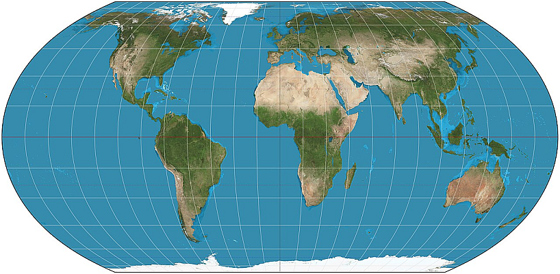
The UN General Assembly has just taken a significant step toward correcting distortions found in widely used world maps—particularly the Mercator projection, which is considered an inadequate representation of the relative size of continents and contributes to a diminished perception of Africa and other equatorial regions, according to the official statement.
Concluding the substantive work of its 80th session, which ends on September 8, the Assembly adopted several draft resolutions and decisions. Notable among them was the draft resolution titled “Correcting the Map: Rebalancing Global Cartographic Representation and Promoting Equitable Representation of World Regions, Particularly Africa,” approved with 164 votes in favor, 1 against (the United States), and 6 abstentions (Estonia, Georgia, Lithuania, the Republic of Moldova, Serbia, and Ukraine).
The text calls for wider use of equal-area map projections—specifically the Equal Earth projection—in contexts where the comparative size of continents is relevant, treating the issue as one that goes beyond a mere technical cartographic problem.
Cognitive justice, historical recognition, and equitable representation
Sponsoring countries argued that distorted maps affect education, public understanding, culture, geopolitics, development narratives, and perceptions regarding Africa’s size and potential. The resolution, therefore, links more accurate cartographic representation to cognitive justice, historical recognition, and equitable representation.
In presenting the text on behalf of the African Group, the representative of Togo stated that the United Nations has been progressively addressing imbalances inherited from the past:
“Today, the issue of maps as a cognitive tool deserves our collective attention. How do we represent the world? How do we teach it? How do generations learn to see our planet?” For centuries, map projections used in textbooks, media outlets, digital platforms, and official documents have distorted the relative sizes of continents, symbolically diminishing Africa and other regions while perpetuating an unbalanced view of global geography.
Expressing support for the text, the representative of the Russian Federation stated that Moscow has consistently advocated for overcoming the legacy of colonialism and combating neocolonial practices. According to him, his country supports the independent efforts of African states to restore historical justice and strengthen Africa’s role as a unique and influential center within the contemporary multipolar world.
Map projections
Map projections are mathematical transformations that allow the Earth’s curved surface—defined by a geodetic model such as a reference ellipsoid—to be represented on a flat plane. They establish a relationship between geographic coordinates (latitude and longitude) and planar coordinates (typically expressed as X and Y).
Since it is impossible to project a curved surface onto a plane without deformation, each projection exhibits different patterns of distortion regarding area, shape, distance, scale, and direction. Therefore, the choice of projection must take into account the territorial extent, scale, and purpose of the mapping, prioritizing the geometric property most relevant to the specific application.
With information from the UN
Cover image: Wikimedia Commons