Drones and Robotics
Space
eVTOL
Geointelligence
Newsletter
WhatsApp
Exhibitions
DroneShow Robotics
MundoGEO Connect
SpaceBR Show
Expo eVTOL
Exhibitors
Lives
Videos
Webinars
About Us
Social Networks
Exhibitors
processing
Drones and Robotics
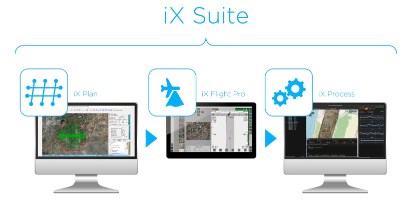
Phase One Announces iX Suite for Seamless Aerial Mapping Workflow
Drones and Robotics
Webinar: Processing Large Drone Projects
Drones and Robotics
Aibotix and Intergraph join forces
News
GCS hires naval veteran as director of business development
News
Spar Europe & European LiDAR mapping conference begins on monday
News
Maptek I-Site 3D technology used to model Mount Panorama race circuit
Drones and Robotics
Gexcel to Release 3D Software for UAV at Intergeo
News
The OGC requests comment on the Scaling Extension to the OGC WCS Interface Standard
News
The OGC requests comment on the range subsetting extension to the WCS standard
News
Orbit GT releases Orbit GIS 10.1
News
Blue Marble to exhibit at the 2012 International LiDAR Mapping Forum
News
Indra leads development of the ground segment of satellite Paz
News
SuperGIS Desktop selected by public works department in India
News
Blue Marble to feature Enhanced ArcMap Extension at the Esri Survey Summit
News
UAV data filters for EnsoMOSAIC
News
SuperGIS Server 3 to support Map Cache
Editorials
Drones and Robotics
eVTOL
Geointelligence
Space
Live Schedule
02 June 2026 - 15h00
Desenvolvimento do ecossistema de eVTOLs: o ponto de vista das autoridades aeronáuticas
26 May 2026 - 11h00
Além do voo – geotecnologias em foco
Video
2025 Feira/Exhibition MundoGEO Connect | DroneShow Robotics | SpaceBR Show | Expo eVTOL
Sign up for our newsletter
Enter your email
Invalid Email
Calm down, we will not share with any third parties.
Confirm Subscription