

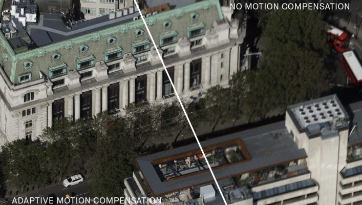
Vexcel Imaging proudly presents a revolutionary new feature, the Adaptive Motion Compensation (AMC), that Vexcel has introduced exclusively for 4th generation UltraCam aerial sensors. AMC is an innovative motion compensation approach that in addition to correcting image blur in the direction of flight (the so-called Forward Motion Compensation or FMC) also addresses blur caused by multi-directional camera movements during the flight. Additionally, AMC compensates for ground sampling distance variations in oblique imagery with fantastic results – through AMC, the 4th generation UltraCam produces imagery of unprecedented vividness and sharpness!
The operating principle is based on using high frequency inertial measurement Unit (IMU) data to record the camera movement during the exposure. This information is used in a non-blind deconvolution algorithm to calculate a filter kernel which removes the motion inducted image blur, regardless of its direction. Compared to mechanical FMC implementations, a software-based approach also has the advantage that no moving parts are needed and thus no abrasion exists. The combination of reasonable fast exposure times, high dynamic range CMOS sensors and AMC creates an unprecedented level of quality, consistency, and mission efficiency.
With the introduction of Adaptive Motion Compensation, Vexcel Imaging is starting a new chapter in motion compensation. Utilizing this innovative method to successfully compensate for multi-directional motion is a game changer for the industry.
The first aerial camera that offers this industry-leading new feature is the UltraCam Osprey 4.1. The 4th generation aerial camera has been launched in 2020 and pushes flight collection efficiency to new levels. The Osprey 4.1 is a highly versatile system and able to simultaneously collect photogrammetric-grade nadir images (PAN, RGB and NIR) and oblique images (RGB) in four directions. Typical applications range from Smart City projects and 3D city modelling to traditional mapping.
The UltraCam aerial camera portfolio is rounded off with Vexcel’s photogrammetry post-processing software UltraMap. The latest version 5.3 of this most-efficient photogrammetry software is released and generates point clouds, comprehensive DSMs and DTMs, ortho imagery and 3D textured TINS.
About Vexcel Imaging
Vexcel Imaging, a leader in the geospatial industry, develops cutting-edge large-format aerial cameras and photogrammetric software with innovative approaches, and places an emphasis on continuing product upgrades and world-class support. The broad UltraCam aerial camera portfolio covers all applications in airborne photogrammetry — from nadir to oblique to wide-area data collection. UltraCam data is processed with the UltraMap photogrammetry software, providing an end-to-end processing workflow for highly automated, quality data products that include point clouds, digital surface and terrain models, orthophotos and 3DTINs.
For more information about Vexcel Imaging’s products, visit www.vexcel-imaging.com!


